This post follows a walk we did taking in some of the ground described in Sidney Rogerson's well known book "Twelve Days". The book describes a front line tour of the trenches, moving up from rest, holding the line, relief and moving back into rest. We set off from Guedecourt, in what felt like a gale, along with persistent drizzle, walked up to the area described in Rogerson's book, round to Lesboeufs and back to Guedecourt. The mud around Gueudecourt was unbelievable, almost as described in Rogerson's book, like "walking through caramel. At every step the foot stuck fast, and was only wrenched out by a determined effort, bringing away with it several pounds of earth".

Rogerson belonged to 2nd Battalion West Yorkshire Regt. Early in November 1916, the Battalion received orders to take over the front line. The Battalion moved up the line in stages, leaving the Citadel Camp where it was in rest, up to "Camp 34" which Rogerson describes as being between Bernafay and Trones wood. He goes onto to state that " "Camp 34" itself was a camp in name only - a few forlorn groups of rude tarpaulin-sheet shelters huddled together, as though they shrank from the surrounding desolation. One or two bell-tents there were, it is true, here and there, but even they looked unhappy as if they knew themselves to be but insecurely at anchor in the rising sea of mud".

A couple of days later, Rodgerson had a 5am start, going up to the area of the Battalion was to take over with the Colonel and other officers, in order to get an understanding of the line.
The sector the Battalion was taking over was between "what remains of the villages of Lesboeufs and Le Transloy....and the ground, which had only been won after stubborn local fighting, has been so pounded that, except for short lengths of German line, anything in the nature of a trench is non-existent".
Rodgerson describes entering the front line area: "We crossed a low valley where the shell-ploughed ground was carpeted with dead, the khaki outnumbering the field-grey by three to one. There must have been two to three hundred bodies lying in an area of a few hundred yards." Rodgerson's position was on the other side of the ridge, facing Le Transloy and the Bapaume Road. It was in view of " Cemetery Circle", the civilian cemetery at Le Transloy which was a German strongpoint.


Rodgerson describes the view as "mile upon mile of emptiness, with never a house or a tree, a hedge or spot of green to break the absolute monotony of tint and feature". On the damp grey day we trudged around the area, it still seemed to fit Rodgerson's description!


Above: Somme Mud and a perhaps evidence of a collapsing dugout?
Rogerson belonged to 2nd Battalion West Yorkshire Regt. Early in November 1916, the Battalion received orders to take over the front line. The Battalion moved up the line in stages, leaving the Citadel Camp where it was in rest, up to "Camp 34" which Rogerson describes as being between Bernafay and Trones wood. He goes onto to state that " "Camp 34" itself was a camp in name only - a few forlorn groups of rude tarpaulin-sheet shelters huddled together, as though they shrank from the surrounding desolation. One or two bell-tents there were, it is true, here and there, but even they looked unhappy as if they knew themselves to be but insecurely at anchor in the rising sea of mud".
Trones Wood (left) and Bernafay Wood (right) - "Camp 34" was situated somewhere between the two woods.
A couple of days later, Rodgerson had a 5am start, going up to the area of the Battalion was to take over with the Colonel and other officers, in order to get an understanding of the line.
The sector the Battalion was taking over was between "what remains of the villages of Lesboeufs and Le Transloy....and the ground, which had only been won after stubborn local fighting, has been so pounded that, except for short lengths of German line, anything in the nature of a trench is non-existent".
Rodgerson describes entering the front line area: "We crossed a low valley where the shell-ploughed ground was carpeted with dead, the khaki outnumbering the field-grey by three to one. There must have been two to three hundred bodies lying in an area of a few hundred yards." Rodgerson's position was on the other side of the ridge, facing Le Transloy and the Bapaume Road. It was in view of " Cemetery Circle", the civilian cemetery at Le Transloy which was a German strongpoint.
Above: The valley described in Rodgerson's book
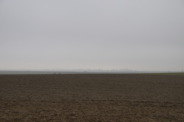
Rodgerson describes the view as "mile upon mile of emptiness, with never a house or a tree, a hedge or spot of green to break the absolute monotony of tint and feature". On the damp grey day we trudged around the area, it still seemed to fit Rodgerson's description!
Above: "mile upon mile of emptiness"
We had a brew up at The Guards Cemetery, Lesboeufs, a welcome break from the wind and drizzle!
Above: Guards Cemetery, Lesboeufs
Comments
Post a Comment