Exercise Force Donnerwetter

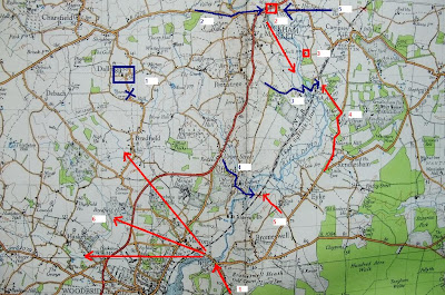
Continuing on the Wilford Bridge theme after last weeks discovery, this post is about a training exercise held on Sept 9th 1940. This exercise envisaged a successful enemy sea-borne landing at Bawdsey. This was followed by an airborne landing at Sutton Walks - this airborne force (Donnerwetter Force) was to seize and hold Wilford Bridge, making good the bridgehead over the River Deben. For the purpose of this exercise, Force Donnerwetter consisted of 120 'parachute' troops, 20 bren carriers, 60 motor cyclists, 20 engineers, one vickers mg platoon and two mortars. Force Donnerwetter 'landed' at Sutton Walks at 0830 hrs and by 0930 had seized Wilford Bridge (1). Reconnaissance units were sent out to hold off the enemy until the main sea-borne force could arrive. Home Force Reconnaissance units were ambushed and destroyed at Wickam Market Bridge (2,2) and by a force at Quill Farm (3). The main British Forces were delayed by a 'fake' despatch rider who told the Home Forces that a rail crash had closed the Melton Level crossing and that the road (1) was no longer usable!
At 1145 Home Forces succeeded in crossing the Deben at Ash (3) and as a result the 'enemy' rushed up reserves from Rendlesham (4). Fierce 'fighting' resulted around Copperas Wood - the Home forces were also attacked from the rear by some carriers coming south from Wickham Market (2). By 1305, Home Forces had retaken Wickam Market Bridge from the east (5) and at  1400 also crossed the Deben at Ufford (4) and more enemy reserves were rushed up (5). 
It was not until 1505 that Force Donnerwetter was overwhelmed and the Wilford Bridge secured (by which time according to the narrative the enemy had already crossed with 8 coy's of tanks which were plunging deep into Suffolk - 6).
I must admit that I did not really take much notice on training exercises from the Home Force War Diaries during my visits to The National Archives (will have to revisit) - although from memory most diaries just give the objectives of the exercise and lack the detailed feedback narratives, such as the one from Exercise Force Donnerwetter.
Coloured numbers correspond to those on the map below (red = Force Donnerwetter, blue = Home Forces).
Image 1: Map of Exercise Force Donnerwetter
Image 2: Bridge over River Deben at Ash
Image 3: Copperas Wood, with the road from Rendlesham
Image 4: Bridge over Ufford
Image 5: Possible loop-holed wall (Rendlesham) - recorded just in case I come across information in the future!


Comments

Popular posts from this blog

Eastern Command Line - a lazy post

As the title suggests, just a lazy post today, a few pics of CRE Colchester design pillboxes in the Sudbury area to round of the thread on this May visit. Also one pic of concrete road block cylinders now being used as part of river bank defences. This is the first time I have come across this type of road block in Suffolk although I suspect it was probably used quite widely on this Stop Line, perhaps I will come across more examples / references in time. These pictures do show a timeless landscape - traditional floodplain meadows still used for grazing, with the Second World War clearly marking its presence. Lets just hope both the pillboxes and  grazing meadows will be preserved.

RAF Hethel Defence Post

At RAF Station Hethel, a remarkable defence post still exists.  Admittedly, RAF Hethel is in Norfolk and not Suffolk, but the records for this site do provide some interest in relation to the defence of airfields in Eastern Command. Work on Hethel began in 1941 and the station was opened late 1942 and was actually one of the RAF Stations handed over to the USAAF for the use of its bomber units. The defence post was constructed in accordance with a new policy adopted by Eastern Command. Previously, airfield defences had been built as a result of the Taylor Report and largely consisted of pillboxes and breastworks which were large and conspicuous and vulnerable to air attack. Experience at Crete had shown the need for small inconspicuous field works. The new defences were to now consist of small two man weapon-slits and small machine gun pits constructed in accordance with “Infantry Training, 1937” Supplement No.3 – “The design and lay-out of Field Defences, 1942”. Above...

Anti-tank ditch

December 31st Decided to visit the anti-tank ditch at Aldringham Walks this afternoon. It was constructed between late 1940 and early 1941 and ran from (north to south) Sizewell to the north of Thorpeness Mere. Some of its length is still visible today (see map and bottom photo)). The war diary of 9th Cameronians (15th Div) mentions the construction of the ditch in Margaret Wood (vicinity of No 12 Platoon, B Coy).  The diary also mentions a pillbox being destroyed by the RE in No 12 platoons area, but no luck in finding any remains this time. The diary would also indicate the ditch was a combined obstacle with Z1 scaffolding. The top left photo shows the remains of a weapons pit/shell slit; six pieces of angle iron revetment still exist - one of the pieces is clearly visible in the photo. Perhaps this is part of No 12 platoons position. Many years ago when beating up the young woodland I found a Yorkshire billhook with the WO arrow dated 1946, so this area would appear to have ...