
Anti-landing trenches, Westleton Walks

Spent a pleasant Monday last week mapping the anti-landing trenches at Westleton Walks. These trenches are unusual compared to those I've mapped to date. Although laid out in the grid pattern, they have been dug in two forms:

  • the usual form I've seen, with spoil in heaps a little back from the trench
  • the spoil placed as a 'lip' to the trench


Above: Google sketchup representations of anti-landing ditches. Top is typical with soil in heaps set back from the trench. Bottom shows the spoil placed in 'lips' - the first time I've come across this.


In one stretch of  trench, it changes from spoil in heaps to a lip mid way. In another stretch, the lip is only one one side for part of the trench, with a much shallower depth of  trench along this section.


Above: GPS map of anti-landing trenches, Westleton Walks

I have an aerial photo of these trenches taken in 1946 (not sure of copyright so cannot post it) and it clearly shows the ditches in this form at least at the end of the War. My only thoughts so far to explain the above is that possibly the usual form (spoil in heaps) was dug by excavator while the spoil in lips sections dug by hand. Maybe the short section with a lip on only one side was never completed (or possibly part in-filled from one side post War?).

The aerial photo also sadly  shows that these are only partial remains of the anti-landing obstacles. I did come across shallow depressions which I thought at the time may be in-filled ditches - will have to go back at some point and map these and over lay them on the aerial photo to be sure.

After mapping the ditches, a little explore revealed a typical 6'x2' slit trench and 6'x4' weapons-pit along with a few bits of angle iron and the remains of a 4" mortar round. Also many circular depressions, probably shell holes. The aerial photo also shows what appear to be shell holes. These are the first positive remains I've found for training in this particular area of Westleton Walks to date.

Below:
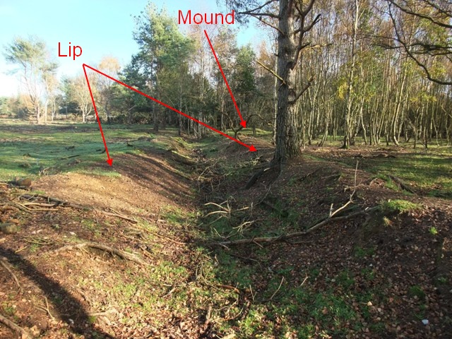
Image 1: Anti-landing ditch with spoil placed in 'lips'
Image 2: Anti-landing trench with spoil placed in mounds
Image 3: Section of trench which changes from spoil in 'lips' to spoil in mounds mid way along its length
Image 4: Section of anti-landing trench with two bits of angle iron nearby
Image 5: Remains of 4" mortar round


Comments

  1. Hi Dave, Just writing a report on WWII airfields for Cadw and wondered if I could use your excellent sketchup representation to show how anti-landing trenches were formed.
    Best Wishes
    GGAT

    ReplyDelete
  2. Hello GGAT, please feel free to use,
    Regards
    Dave

    ReplyDelete

Post a Comment

Popular posts from this blog

Eastern Command Line - a lazy post

As the title suggests, just a lazy post today, a few pics of CRE Colchester design pillboxes in the Sudbury area to round of the thread on this May visit. Also one pic of concrete road block cylinders now being used as part of river bank defences. This is the first time I have come across this type of road block in Suffolk although I suspect it was probably used quite widely on this Stop Line, perhaps I will come across more examples / references in time. These pictures do show a timeless landscape - traditional floodplain meadows still used for grazing, with the Second World War clearly marking its presence. Lets just hope both the pillboxes and  grazing meadows will be preserved.

RAF Hethel Defence Post

At RAF Station Hethel, a remarkable defence post still exists.  Admittedly, RAF Hethel is in Norfolk and not Suffolk, but the records for this site do provide some interest in relation to the defence of airfields in Eastern Command. Work on Hethel began in 1941 and the station was opened late 1942 and was actually one of the RAF Stations handed over to the USAAF for the use of its bomber units. The defence post was constructed in accordance with a new policy adopted by Eastern Command. Previously, airfield defences had been built as a result of the Taylor Report and largely consisted of pillboxes and breastworks which were large and conspicuous and vulnerable to air attack. Experience at Crete had shown the need for small inconspicuous field works. The new defences were to now consist of small two man weapon-slits and small machine gun pits constructed in accordance with “Infantry Training, 1937” Supplement No.3 – “The design and lay-out of Field Defences, 1942”. Above...

Anti-tank ditch

December 31st Decided to visit the anti-tank ditch at Aldringham Walks this afternoon. It was constructed between late 1940 and early 1941 and ran from (north to south) Sizewell to the north of Thorpeness Mere. Some of its length is still visible today (see map and bottom photo)). The war diary of 9th Cameronians (15th Div) mentions the construction of the ditch in Margaret Wood (vicinity of No 12 Platoon, B Coy).  The diary also mentions a pillbox being destroyed by the RE in No 12 platoons area, but no luck in finding any remains this time. The diary would also indicate the ditch was a combined obstacle with Z1 scaffolding. The top left photo shows the remains of a weapons pit/shell slit; six pieces of angle iron revetment still exist - one of the pieces is clearly visible in the photo. Perhaps this is part of No 12 platoons position. Many years ago when beating up the young woodland I found a Yorkshire billhook with the WO arrow dated 1946, so this area would appear to have ...