
Visit to Loos - Hohenzollern Redoubt and Hulluch Quarriis

Had a very interesting day at Loos on our recent trip to France. A walk around the Hohenzollern Redoubt and the edge of the Quarries revealed some new remains that we had not seen before. This area was at the heart of the Battle of Loos in 1915. The area was the scene of initial success but following fierce fighting the Germans managed to regain lost ground. The lines then settled down for the next three years, with incessant mining and trench warfare.  Unfortunately the weather was misty on our visit so some of the photos are not that great. 

Below: Trench map of the lines in the Hohenzollern Redoubt and Quarries area before the battle.


Below: Trench map at the end of the Battle. The lines were to remain so for the next three years, with some intense mine warfare as can be seen by the craters marked on the map. Some very good remains of the German front line, which include, trenches, dugouts, mine craters and remains of concrete emplacements can be seen today in woods just to the west of the Quarries. 


Below: Some of the remains of the German front line as it was after the battle had died down. Remains of a concrete structure in the front line trench can be seen, as well as dugouts, screw pickets and some impressive mine craters. 7th Suffolks were in this area during October 1915 - did not realize at the time, should have done my homework before the visit!!


Below: A couple of German observation posts, constructed on the front German Line after the battle had died down. 


Below: Some views of the battlefield. First image shows the dominating position of the Hohenzollern Redoubt (the clump of trees on the high ground in the extreme background of the image), taken from what was no mans land in 1916. Second image shows the view from the German perspective, image taken from approx Big Willie / South Face trenches on the Redoubt. Last image shows a role of barbed wire, the Redoubt in the background (clump of trees).


Next two images show Quarry Cemetery,  established due mainly to the fighting for the Hohenzollern Redoubt (and Fosse 8). Contains may graves of cavalry units, employed as infantry. 


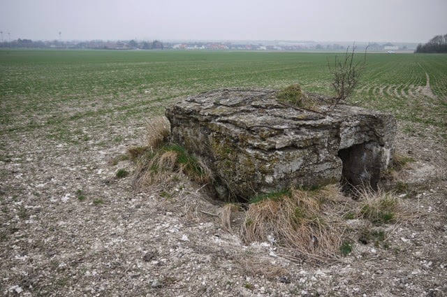
Final shots show some of the other areas we visited on the day. They include another German observation pillbox constructed on Hill 70 after the battle had died down, Dud Corner Cemetery (name given to it because of the number of dud shells fired on this spot during the battle) and Philosophe Cemetery (bottom image) - a new cemetery for me. Philosophe cemetery was taken over by the 16th Irish Division in 1916 who held the Loos salient at that time.


Only a whistle stop tour of our day at Loos I realize, we did visit other areas but the images are crap because of the mist! We hope to revisit next year, so hopefully a more detailed post then.


Comments

Popular posts from this blog

Eastern Command Line - a lazy post

As the title suggests, just a lazy post today, a few pics of CRE Colchester design pillboxes in the Sudbury area to round of the thread on this May visit. Also one pic of concrete road block cylinders now being used as part of river bank defences. This is the first time I have come across this type of road block in Suffolk although I suspect it was probably used quite widely on this Stop Line, perhaps I will come across more examples / references in time. These pictures do show a timeless landscape - traditional floodplain meadows still used for grazing, with the Second World War clearly marking its presence. Lets just hope both the pillboxes and  grazing meadows will be preserved.

RAF Hethel Defence Post

At RAF Station Hethel, a remarkable defence post still exists.  Admittedly, RAF Hethel is in Norfolk and not Suffolk, but the records for this site do provide some interest in relation to the defence of airfields in Eastern Command. Work on Hethel began in 1941 and the station was opened late 1942 and was actually one of the RAF Stations handed over to the USAAF for the use of its bomber units. The defence post was constructed in accordance with a new policy adopted by Eastern Command. Previously, airfield defences had been built as a result of the Taylor Report and largely consisted of pillboxes and breastworks which were large and conspicuous and vulnerable to air attack. Experience at Crete had shown the need for small inconspicuous field works. The new defences were to now consist of small two man weapon-slits and small machine gun pits constructed in accordance with “Infantry Training, 1937” Supplement No.3 – “The design and lay-out of Field Defences, 1942”. Above...

Anti-tank ditch

December 31st Decided to visit the anti-tank ditch at Aldringham Walks this afternoon. It was constructed between late 1940 and early 1941 and ran from (north to south) Sizewell to the north of Thorpeness Mere. Some of its length is still visible today (see map and bottom photo)). The war diary of 9th Cameronians (15th Div) mentions the construction of the ditch in Margaret Wood (vicinity of No 12 Platoon, B Coy).  The diary also mentions a pillbox being destroyed by the RE in No 12 platoons area, but no luck in finding any remains this time. The diary would also indicate the ditch was a combined obstacle with Z1 scaffolding. The top left photo shows the remains of a weapons pit/shell slit; six pieces of angle iron revetment still exist - one of the pieces is clearly visible in the photo. Perhaps this is part of No 12 platoons position. Many years ago when beating up the young woodland I found a Yorkshire billhook with the WO arrow dated 1946, so this area would appear to have ...