
Somme trip: Sun 21st March

A walk today around  Serre, then over the Redan Ridge to Beaumont-Hamel in the morning. In in afternoon a walk around the area of Newfoundland Park.
Serre, a German Fortress village, was the northern limit  of the 1st July attack (a diversionary attack was made a little further north at Gommecourt). At Serre, the British had to attack up gently sloping ground towards the German line and most were annihilated within minutes by German machine guns which had not been dealt with during the preliminary barrage.
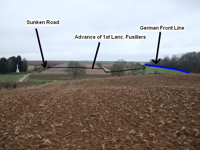
Beaumont-Hamel was another German position of incredible strength. The village itself sat in a hollow between the Hawthorn and Redan Ridges and was flanked by machine guns on both ridges. A huge mine was blown under the redoubt on Hawthorn ridge, but the British were unable to seize the crater, allowing the Germans to re-establish machine guns in the position. It is easy here to visualize the attack of the 1st Lancs. Fusiliers, 86th brigade, 29th Div. They had tunnelled from the British front line to occupy  a sunken road prior to the start of the attack on 1st July, had then to advance over an open field, then drop down a bank before advancing up a gentle slope towards the German front line. The battalion was cut to pieces in minutes of leaving the sunken lane.
Newfoundland Park is a memorial park to the Newfoundlanders. The 1st Newfounland Battalion, part of 88 Brigade (the reserve Brigade of 29th Div),  were ordered to attack despite the complete failure of the two main attacking brigades due to incorrect reports of troops fighting in the German reserve positions. The 29th Div history describes eyewitness accounts of the battalion advancing 'undaunted by a hail of machine gun fire' until only a hadfull of men were left (they suffered 90% casualties). Today the park is a preserved part of the battlefield (although actually from the 1918 lines). 
From the area of the park, good views across the Ancre Valley of Thiepval are to be had. In the bare fields, chalk marks can clearly be seen, actually the remnants of the chalk spoil from the deep German front line trenches and dugouts.
Image No 1: Unexploded shell, from approx approx German Front Line at Serre, overlooking British Front Line (the copses in the background)
Image No 2: Taken from German Front line, Beaumont Hamel. The cemetery is in no-mans land and the memorial and hedgerow in the background is the location of the sunken lane.
Image No 3: Remains of German Front Line, Beaumont-Hamel
Image No 4: 1st Lancs. Fus. attack, Beaumont-Hamel
Image No 5: Newfoundland Memorial Park
Image No 6: Newfoundland Memorial Park
Image No 7: Thiepval, across the Ancre Valley from vicinity of Newfoundland Park. The German Front line can be followed in the bare fields as chalk marks.


Comments

Popular posts from this blog

Eastern Command Line - a lazy post

As the title suggests, just a lazy post today, a few pics of CRE Colchester design pillboxes in the Sudbury area to round of the thread on this May visit. Also one pic of concrete road block cylinders now being used as part of river bank defences. This is the first time I have come across this type of road block in Suffolk although I suspect it was probably used quite widely on this Stop Line, perhaps I will come across more examples / references in time. These pictures do show a timeless landscape - traditional floodplain meadows still used for grazing, with the Second World War clearly marking its presence. Lets just hope both the pillboxes and  grazing meadows will be preserved.

RAF Hethel Defence Post

At RAF Station Hethel, a remarkable defence post still exists.  Admittedly, RAF Hethel is in Norfolk and not Suffolk, but the records for this site do provide some interest in relation to the defence of airfields in Eastern Command. Work on Hethel began in 1941 and the station was opened late 1942 and was actually one of the RAF Stations handed over to the USAAF for the use of its bomber units. The defence post was constructed in accordance with a new policy adopted by Eastern Command. Previously, airfield defences had been built as a result of the Taylor Report and largely consisted of pillboxes and breastworks which were large and conspicuous and vulnerable to air attack. Experience at Crete had shown the need for small inconspicuous field works. The new defences were to now consist of small two man weapon-slits and small machine gun pits constructed in accordance with “Infantry Training, 1937” Supplement No.3 – “The design and lay-out of Field Defences, 1942”. Above...

Anti-tank ditch

December 31st Decided to visit the anti-tank ditch at Aldringham Walks this afternoon. It was constructed between late 1940 and early 1941 and ran from (north to south) Sizewell to the north of Thorpeness Mere. Some of its length is still visible today (see map and bottom photo)). The war diary of 9th Cameronians (15th Div) mentions the construction of the ditch in Margaret Wood (vicinity of No 12 Platoon, B Coy).  The diary also mentions a pillbox being destroyed by the RE in No 12 platoons area, but no luck in finding any remains this time. The diary would also indicate the ditch was a combined obstacle with Z1 scaffolding. The top left photo shows the remains of a weapons pit/shell slit; six pieces of angle iron revetment still exist - one of the pieces is clearly visible in the photo. Perhaps this is part of No 12 platoons position. Many years ago when beating up the young woodland I found a Yorkshire billhook with the WO arrow dated 1946, so this area would appear to have ...