I have visited these defences a few time,
all that now remains of the defences of RAF Martlesham Heath, but learning that
the site is included in the plans for thousands of new homes at Martlesham, I
decided to record the remains in a bit more detail as it is hard to see them
being preserved if the Planning Permission goes ahead, which is likely. The following posts includes the recording on
this visit plus some images from previous visits.
The site includes a Type 22 pillbox, Type
23 pillbox, remains of a building with a loopholed wall and remains of
weapon-pits / slit trenches. It was once possible to see the pillboxes as you
drove past on the A12 but a bank now screens the field from the road; not sure
if this is to do with the planned houses or screening the nearby quarry. Anyway, one building has been destroyed with
building a bank in the field.

Above: The area today, soon to be part of a housing estate?
Type 22 pillbox: A very good and clean
example. It is built on a mound (tumulus?) presumably to give it a commanding
position. There are also remains of brick walls on the mound, one which seems to
run partly way round the base of the mound (remains of brick lined trench?),
one possibly the remains of a shelter.


Above: The Type 22 pillbox. Bottom image is a plan showing the pillbox and remains of brick walls.
Type 23 pillbox, dugout and slit trenches:
A Type 23 pillbox is associated with a brick built dug out and remains of
weapons-pit/slit trenches. The pillbox
is sunken to embrasure level. The dug out is of a “cut and cover” type, constructed
with brick (9” thick walls) and has a 6” concrete roof. There
is what seems to be a window in one side of the dugout at ground level. The entrance has the remains of a 3” wooden
lintel. The dimensions of the dugout are virtually identical to the dugout at
Hethel in which I recently posted about. Perhaps the defences developed over
time, the dugout and slit trenches added later than the pillbox? If so the
question remains why place them so close to the pillbox, which would draw
attention to them? If this was the case the answer is probably that the pillbox
was located in the ideal fire position. The remains of the slit trenches
consist of angle iron and corrugated iron sheet revetment. The remains of what is probably another dugout
and associated slit trenches are nearby.


Above: Top image shows plan of Type 23 pillbox, dugout, angle iron pickets and corrugated sheet revetment.
2nd image shows Type 23 pillbox - note the remains of a Stanton Air Raid Shelter dumped on top.
3rd and 4th image shows the remains of the slit trenches; image no 4 was taken a few yrs ago, note how much better preserved the corrugated sheets and pickets were then.
5th and 6th image show the dugout.
7th, 8th and 9th image show plan and images of the remains of a second defence position nearby, probably consisting of a "cut and cover" dugout and slit trenches.
Defended building: Remains of the
foundations of an octagonal building given an outer skin brick wall which is
loopholed on five sides. Not sure what
the building was used for.


Above: Sketch and images of loopholed building. The last three images were taken several years ago, just after the scrub had been cleared from the remains.
Destroyed building: Not sure what the
purpose of the building was.

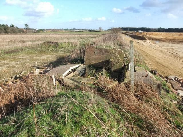
Above: Destroyed building, as it was a few years ago and today.
Finds: Finds in the field nearby the
defences included some period pottery and a charger clip for loading a rifle
although not sure which rifle (not a .303); maybe post war.


Remains found in the area a few years ago
Hi Dave, We "MHAS" have now listed these and other "buildings and remnants" into the Village Plan which has been accepted and goes to Parliament shortly. Although there has been one move outside the Plan already!! Some of us at MHAS are taking an interest in the Airfield Defences and how they linked in with the Coastal defences, and how it was all manned and organised. So will let others know about your very interesting site, Thank You Ian (Museum Manager)
ReplyDelete